LeBreton Flats Sprint Summer Orienteering
August 27th 2024 4:30pm - 7:45pm
Map: LeBreton Flats
This event will conclude the Summer Sprints and will be run quite differently.
This will be a free event for all. There will be no timing or controls out there, just ribbons (you must touch the ribbon to be counted). If you ever went to a Thursday night training session this will be very similar. The LeBreton map contains optimal sprint terrain that we seldom notice and will be fun for everyone.
Next Tuesday, August 27 you can start as early as 4:30. Limited parking is available on Fleet Street so we recommend carpooling, biking or taking the train to Pimisi Station.
Two sprint courses will be offered. If you want to do both, only the first one will count in your results. Both have similar parts, so don’t get confused thinking someone is on your course when they are not. Please be careful if close to construction zones.
If you wish your results to be compared with others, touch the flags, bring a watch and give your time to the finish person who will post the times on our website. We will also have someone on timing to cross-reference.
Daniel Mahoney & Linda Connell
Location: Limited parking on Fleet Street
Registration: free! – there is no registration. Maps will be given out at the start.
Start: anytime between 4:30 – 7pm.
The start is east of the Holocaust Museum. Cross the Parkway (Kichi Zibi Mikan) at the cross walk from Fleet Street. We are looking into alternate parking as well.
Last Start: 7pm
Course Closes: 7:45pm. Controls will be picked up at 8pm.
Map: LeBreton Flats
Scale: 1:4,000
Contours: 2m
Short: 2.1km, 15 controls
Long: 3.2km, 20 controls
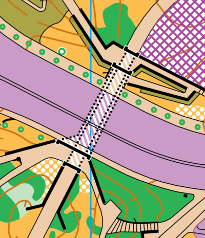
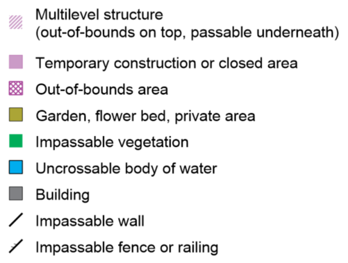
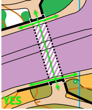
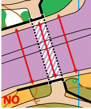
Wellington St. and Portage Bridge are out of bounds (purple on the map), that means during the course are not allowed to cross over top of them. You can however pass through the tunnels underneath. This map has a new symbol for multilevel structures (2 or more surfaces above one another). White hatch on the map. Tunnels are mapped using this symbol.
Here is an example of where you can and cannot run.
If that isn’t complicated enough for you, there is an area on the map where there are two tunnels stacked on top of one another that go under a road. It is mapped like this.